GENERAL
The Imogene Pass Run (IPR) is a 17.1 mile point-to-point mountain race within the western San Juan mountains of Colorado, run along a route which connects the towns of Ouray (7810 ft.) and Telluride (8750 ft.) by way of 13,114 foot Imogene Pass. The IPR is held on the first Saturday after the Labor Day holiday, at the seasonal transition from late Summer to early Fall. Mountain weather at this time is famously “squirrelly” (rapidly changeable), and participants through the years have encountered a variety of weather conditions ranging from virtually perfect to terrible. This spectrum of weather during the race is in fact part of its lure and mystique. In good weather years the challenge of the mountainous traverse is rewarded by unsurpassed vistas and no small feeling of accomplishment upon crossing the finish line. In bad weather years, the wind, fog, rain and/or snow along the course make the successful arrival in Telluride a virtual rite of passage into the realm of true mountain running.
Each participant should keep in mind that the IPR is a mountain run in every sense of the word, and that “The Mountains Don’t Care”. The reality is that despite whatever emotions we may have for the mountains and their environment, they are in fact unfeeling objects and they follow the natural rules of physics which are not always benevolent toward living creatures, great or small. It is up to the participants themselves to be properly prepared for the challenges of this alpine foot journey, fair weather or foul. Despite the enthusiastic volunteer support at intervals along the course, each participant is ultimately responsible for his or her own safety and risk.
Except for short pavement stretches at the start and finish and a short trail section immediately below the pass, the IPR is run along a course consisting of normal to 4×4 dirt road. This is a traditional summer travel way between Ouray and Telluride and there may be minor vehicle traffic during the race. A total of six aid stations will be manned during the race (including one at the summit), support personnel will be stationed at critical junctions along the course, and numbered orange traffic cones will be placed at every mile interval from the start to the finish.
THE SETTING
The mountainous setting of the IPR is impressed upon the participants as they assemble in Ouray at the starting line. As they gaze upon the peaks which rise steeply on three sides above town, they are faced with the realities of the alpine environment through which they will soon find themselves moving as they negotiate the rocky route from one mountain town to another. At some of the yearly runnings the day dawns clear and cool with the promise of inspirational views; more often there is a mixed message with variable wind and skittish clouds moving among the peaks; occasionally there is a ominous message as the peaks are obscured at dawn by gray clouds with the promise of rain and snow in the wind. Whatever the weather, this is it, the event for which you have probably long prepared for, a summary test of sorts to gauge your physical and mental status as the seasons begin their timeless change from Summer to Autumn.
As you contemplate the journey ahead, remember: “To get to where you want to go, you have to start from where you are”; and think IFM: “Incessant forward motion”. It is up to you to get yourself, by your own two feet, from Ouray to Telluride. Only through continuous forward motion, even at a walk if necessary, at low or high elevations, on steep or moderate terrain, and in good or bad weather will you arrive at the finish line goal. Then too, one must not forget to “Smell the roses along the way”, and to appreciate the natural and human history through which you will pass, along the way.
The Course
So just how does one get to Telluride from Ouray via Imogene Pass? In a sentence: The runner moves from Main Street, Ouray, 5.5 miles up the Camp Bird road to the Lower Camp Bird mine; then 4.5 miles up the Imogene road past the Upper Camp Bird to the Pass; then 7.1 miles down the Tomboy road to Telluride. A basic list of mileage and references can be found by clicking here. A graphical profile of the course can also be viewed. For those who are interested, the following is a very detailed description of the course and what the runner may expect to encounter along the way.
Mile 0.00, The Start at Ouray— Elevation 7810 ft. (Main Street and Second Avenue)
Mile 0.00– The starting line is at the intersection of Ouray’s Main Street and Fourth Avenue, between the Antlers and Ouray Cottage motels. From the start, participants move south along paved Main Street, two blocks to the edge of town, then turn right on US 550 and begin climbing at a gentle gradient (300 ft./mi., or 5.5% gradient, the normal gradient for Colorado mountain highways).
Mile 0.32– At the beginning of a left hand 180° hairpin curve in the highway, most runners turn 90° left , leave the pavement, pass between some large rip rap boulders, and shortcut cross-country south some 280 ft. to the US 550/ Camp Bird road junction. This shortcut saves 50 yards, but some runners may want to continue on the highway around the curve due to the early race congestion.
Mile 0.37– US Highway 550/Camp Bird road junction. Move due south at the junction onto the Camp Bird road (you will pass a large white highway information sign on your left). If you miss this road junction you will find yourself heading to Silverton instead of Telluride.
Mile 0.44– Camp Bird/ Box Canyon roads junction (Box Canyon Falls sign at junction), 350 feet south along the Camp Bird road from the previous junction. The recommended course is to turn right onto the Box Canyon road, cross a bridge over the Uncompahgre river at 0.48 mi., and then turn left in another 100 feet, just beyond a rustic stone building (once it was a powder or explosives magazine). You are now at the base (7925 ft.) of Jim Brown hill (identity of Jim Brown has been forgotten), and the course begins climbing steeply to the left along an abandoned portion of the Camp Bird road, then switchbacks to the right and arrives at the presently maintained Camp Bird road at Mile 0.61. Continue straight ahead onto and up the maintained dirt road.
A second alternative at the Camp Bird/Box Canyon roads junction is to stay left of the Box Canyon Falls sign, and to move cross-country straight up the fall line on the left side of the deep Uncompahgre slot canyon to the left side of the modern concrete bridge which spans the crevasse. Turn right, cross the bridge and continue up the Camp Bird road. This route is shorter but steeper than the recommended route, and it cannot accommodate as many runners.
Mile 0.90– Summit (8200 ft.) of Jim Brown hill, on the Camp Bird road. You know you have arrived at the summit of Jim Brown hill when you see the large green Ouray city water tank on your left, and the gradient suddenly becomes relatively gentle as the road curves slightly left. You have now completed the first steep climb in the course (275 feet in 0.4 mile from the Powder Magazine; 685 ft./mi. or 13.0% gradient overall). The road climbs gently for the next half mile.
Mile 1.00— Elevation 8230 ft. (Orange cone on left shoulder of road)
Mile 1.50– Base (8370 ft.) of Legal Tender hill, named for the abandoned Legal Tender tunnel located near the top of the hill. The road gradient increases.
Mile 1.79– Summit (8545 ft.) of Legal Tender hill. Similar to but shorter than Jim Brown hill with 175 feet of climb in 0.29 mile (600 ft./mi., or 11.4% gradient overall). The road gradient decreases.
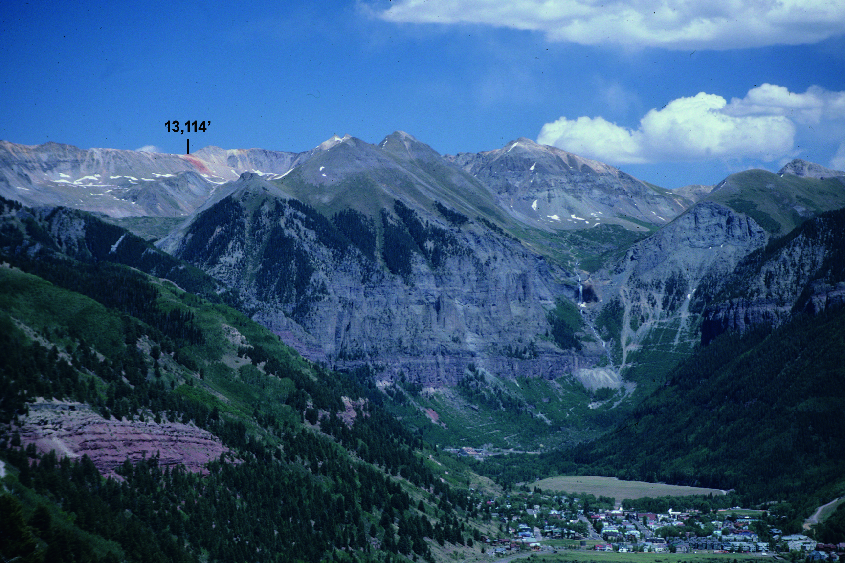
Mile 1.85– First view of United States mountain (13,036 ft.), located straight ahead at the head of Canyon Creek valley. The course will eventually move along the left base of the mountain, into Imogene basin. Keep in mind that Imogene pass is 84 feet higher than the summit of United States mountain, and adjust your effort accordingly. The road is now nearly horizontal and will loose about 25 feet of elevation before arriving at the Harris bridge.
Mile 2.00— Elevation 8540 ft. (Orange cone on left shoulder of road)
Mile 2.29– Harris Bridge (spanning Canyon creek) and Aid Station (8520 ft.). This is the first of six aid stations spread every 2.0 – 2.5 miles along the course. The road climbs moderately steeply through aspen forest for the next 0.7 mile.
Mile 3.00— Elevation 8750 ft. (Orange cone on right shoulder of road)
Mile 3.00– Weehawken trailhead and Thistledown mine camp site. The course continues straight ahead along the Camp Bird road, which climbs 230 feet in the next 0.4 mile (575 ft./mi., or 10.9% gradient overall), before leveling out at Drinking Cup curve.
Mile 3.40– Drinking Cup curve (8980 ft.). The drop off on the left is impressive, the gushing spring on the right provides perfectly good water to drink. The road varies between relatively flat and substantially steep for the next 0.42 mile, to the Senator Gulch culvert.
Mile 3.82– Senator Gulch culvert. This is the base (9135 ft.) of Unconformity hill (named for three distinct geologic unconformities along its course), which will climb 465 feet in the next 0.8 mile (580 ft./mi., or 11.0 % gradient overall).
.
Mile 4.00— Elevation 9180 ft. (Orange cone on left shoulder of road, between two switchbacks)
Mile 4.62– Summit (9600 ft.) of Unconformity hill, at the Water Hole slide run out area. The Water Hole slide is a large avalanche which descends through the narrow slot in the cliffs to the left of the road. The snow depth on the road can be a great as 30 feet after a heavy winter (the road is often in a white walled slot canyon come spring) with one or several runs of the avalanche (not wise to linger here in winter). The road now levels out for a short distance but climbs steeply again past the 5.0 mile marker cone to the Lower Camp Bird aid station.
Mile 5.00— Elevation 9695 ft. (Orange cone on left shoulder of road)
Mile 5.10– Lower Camp Bird (LCB) Aid Station (9765 ft.). This is the Yankee Boy/Imogene roads junction and the runner will notice a distinct change in the ambient conditions from valley to sub alpine. The course will follow the left road and drop slightly to the Lower Camp Bird bridge at Mile 4.45. Aid station volunteers will probably be able to give the runners information as to weather conditions higher along the course.
Mile 5.45– Lower Camp Bird bridge (9755 ft.), spanning Sneffels creek. At this point the runner might philosophize a little and consider just where he or she is in this effort called the Imogene Pass Run. At this bridge you have climbed 1945 feet (net) of elevation in 5.45 miles, at an average of 356 ft./mi., or 6.8% gradient overall. To reach Imogene Pass from here you must climb 3365 feet in the next 4.60 miles, at an average of 731 ft./mi., or 13.85% gradient overall. Your effort so far has simply been a warmup. The steep gradients of the named hills below you are now less than the average gradient ahead of you.
The real mountain running effort now begins. The course turns right past the bridge, climbs steeply straight ahead between two large Victorian-style houses (formerly the Camp Bird Mine’s superintendent’s and manager’s residents), and then turns right at a large boulder immediately after you enter a dense conifer forest. There is a brief break in slope as the road (now a 4×4 jeep road) switchbacks left, and moves in and out of forest southeast along the base of a 150 foot cliff into lower Imogene basin.
Mile 6.00— Elevation 10,115 ft. (Orange cone on right shoulder of road)
Mile 6.15– The course exits for good out of the conifer forest, and the lower portion of the glacially carved Imogene basin opens before you as you move straight ahead past a shelf road coming in on the right. The Imogene road climbs incessantly for the next 0.65 mile across a barren, avalanche scoured slope known as the US slide, another dangerous winter avalanche. The road surface varies between loose gravel-talus, to smooth bedrock, to local soft mud. You are now traversing the east base of United States mountain which you first saw at the summit of Legal Tender hill at Mile 1.85. You may notice the few scanty ruins of the U.S. Depository mine to the right of and above a short horizontal stretch in the road.
Mile 6.85– Cross Imogene creek (10,730 ft.). The road gradient flattens for a short stretch just before Imogene creek, then resumes its now normal steep climb (630 ft./mi., or 12.0% average gradient) as it moves to the east side of the creek, then south along a blasted out shelf in a cliff at the Yellow Rose mine area. There is no bridge at this creek crossing, but the water level is relatively low and there will probably be wooden planks spanning the water.
Mile 7.00— Elevation 10,825 ft. (Orange cone on left shoulder of road)
Mile 7.20– Imogene/Richmond roads junction (10,950 ft.). The bedrock footing and steep gradient of the blasted out shelf road continues to the roads junction at the mouth of Richmond basin on the left. The IPR course moves right at this junction, across a worn wooden bridge to the west side of Imogene creek. There is a permanent sign at the bridge pointing right to Imogene pass (and left to Richmond basin), but some runners nonetheless have followed the Richmond road (wrong!) at times in the past. The Imogene road pauses briefly with a short stretch of moderate gradient on the west side of the creek, then switchbacks right and then left as is resumes its normal steep climb (740 ft./mi., or 14.0% gradient) all the way to the Upper Camp Bird.
Mile 7.65– Upper Camp Bird (UCB) Aid Station (11,235 ft.). The Upper Camp Bird Aid Station is an important mile post in the IPR in that this is the mandatory turn around point for bad weather conditions, or for unprepared or excessively slow runners. The race director has the option of short-circuiting the race at this point in the case of a severe deterioration in the weather (say, fog and excessive fresh snow above timberline, dangerous lightning at the summit, etc.) and turning everyone back to finish at Ouray. Runners who do not have proper clothing in bad weather will be asked to turn back to Ouray at this point. Also, runners who do not arrive at this point by 2:30 after start time required to voluntarily return to Ouray, regardless of the weather. A bus remains in Ouray to take turn-backs to the finish line.
As at the 5.45 mile bridge at the Lower Camp Bird, the runner might philosophize a little here at the Upper Camp Bird, Mile 7.65, and consider just where he or she is in this ongoing IPR effort. At this aid station, you still have 1885 feet to climb in the next 2.4 miles (785 ft./mi., or 14.9% average gradient) before reaching Imogene Pass. In good weather at the Upper Camp Bird , the runner is treated to a spectacular vista of late summer tundra spreading south and upward along the course to the base of the headwall (which separates the lower and upper Imogene basins). To continue to the summit in good weather can be an inspirational experience in which the only complication is likely to be technicolor burnout. In bad weather, the head wall will likely be hidden at this point behind a sea of fog complicated with falling rain and/or snow, with or without wind and/or lightning. To continue in bad weather can mean a serious struggle to locate the route (in case of whiteout) and to avoid hypothermia. In the event some or all participants turn back at the Upper Camp Bird, transportation will be provided from Ouray to Telluride for those who require it.
Meanwhile, we are going to the top. The fun now begins. Enjoy the hospitality at the Upper Camp Bird aid station for a brief moment, then continue on your way. The course immediately crosses to the east side of Imogene creek (no bridge, but wood planks will probably span the water), then resumes its upward climb at 870 ft./mi. (16.5% gradient) for the 0.35 mile to Mile 8. The Imogene road makes a series of switchbacks as you approach Mile 8.0, but the IPR course follows a jeep shortcut (between switchbacks one and two) straight up the fall line to the orange Mile 8.0 cone (This shortcut saves about 100 yards. It is now closed to vehicle traffic but foot traffic is permitted).
Mile 8.00— Elevation 11,540 ft. (Orange cone on right shoulder of road)
Mile 8.00– You are now above tree line and are entering in the true alpine environment with its inspirational vistas but changeable weather. The shortcut road merges with the normal Imogene road, then continues steeply upward without pause (815 ft./mi., or 15.4 % gradient) as it switchbacks, then traverses to the right to the base of and then through the headwall via a blasted out diagonal bench.
Mile 8.92– Summit of the headwall (12,290 ft.). The road curves left as you exit from the diagonal bench through the head wall cliff. The grade slackens, reaches a crest, then drops into a steep trough and coasts gently uphill to the Mile 9.0 cone. It is only natural to hesitate a second or two at this crest, to recover from the climb of course, but especially to gaze at the summit ridge known as Imogene Pass, in plain view at last, straight ahead and 830 feet above.
Mile 9.00— Elevation 12,310 ft. (Orange cone on right shoulder of road)
Mile 9.00– The shallow dip and brief uphill coast ends at this marker cone. Your work is cut out for you in that the road makes up for lost time as it climbs 240 feet in the next 0.24 mile at an average gradient of 1000 ft./mi., or 18.9%.
Mile 9.24– At the top (12,550 ft.) of this nameless hill Imogene Pass beckons, as the road flattens for about 30 yards, then drops into another shallow trough.
Mile 9.30– As with Murphy’s law, nothing worthwhile ever comes without sacrifice. The pass is ever closer, but the effort intensifies as you move out of the trough. The road mounts another effort to repulse you with a merciless hill which climbs 230 vertical feet over the next 0.2 mile (1050 horizontal ft.) at a gradient of 1150 ft./mi. (21.8%).
Mile 9.50– At the top (12,750 ft.) of the merciless hill the road flattens to near level, as if to gather for its final defense. Take a break, recover, but keep moving.
Mile 9.60– The pass is now seemingly within touching distance, but you still have dues to pay. The road steepens again in a final effort to discourage you, presenting a climb identical to the previous merciless hill (195 ft. vertical in 0.17 mi.; 1145 ft./mi., or 21.7% gradient).
Mile 9.77– Even the fittest of mountain runners may consider pausing at the top (12,945 ft.) of this final grind, but only for a second. The road now concedes defeat and presents a gently undulating, near-horizontal coast to the road/trail junction, 400 feet ahead.
Mile 9.85– Imogene road/trail junction (12,990 ft.). From the Upper Camp Bird to this point, the road has followed and obliterated the original pack trail. The course now turns right (there will probably be a temporary direction sign at this point), away from the road, and follows the only surviving remnant of the pack trail. Yes, it is still a climb (130 ft. vertical in 0.12 mi.; 1080 ft./mi., or 20.5% gradient), but you are now on a true mountain trail, and it only seems natural that it will climb.
Mile 9.97– Imogene trail/road junction (13,120 ft.). You have succeeded in gaining the summit. The long climb is behind you. Turn right (west) on the horizontal road for the pass.
Mile 10.00— Elevation 13,120 ft. (Orange cone on left shoulder of road)
Mile 10.05— The Summit at Imogene Pass— Elevation13,120 ft.
Mile 10.05– Imogene Pass and aid station (13,120 ft.). As you move west along the road from the trail/road junction, the road and summit ridge meet. This is Imogene Pass. In good weather it is pleasurable to pause briefly and look back at where you just came from, and forward to where you are heading. Ouray is completely hidden in the deep valley to the northeast, from whence you just came, to the right of the now insignificant appearing United States mountain. Telluride is relatively close to the west, and although the green lower valley and mesas are clearly visible, the town itself is hidden behind nearer high ridges. Even in good weather the aid station volunteers are usually dressed in cold weather clothes at this exposed summit ridge aid station. In mixed or bad weather, you will be doubly thankful for their presence as you briefly partake of their aid and immediately begin your descent.
The IPR course will now use the road exclusively all the way to the finish line in Telluride. At this narrow pass-on-the-ridge known as Imogene, the westerly heading Imogene road makes an abrupt 150°left turn and begins its descent as Tomboy road, south into Savage basin. At 0.25 mile below the pass the road switchbacks right, and the runner moves westerly over loose footing down an unrelentingly steep relatively direct route to the 11.0 mile marker cone. This is the single longest and steepest uninterrupted descent gradient on the course (900 ft. vertical in 0.95 mile; 950 ft./mi or 17.9% gradient). With legs accustomed to moving constantly upward It is easy to loose control in this first downgrade with its steep grade and treacherous footing, so be careful. Most injury falls in the race occur in this stretch.
Mile 11.00— Elevation 12,220 ft. (Orange cone on right shoulder of road)
Mile 11.00– The unrelenting steep downgrade continues at the mile cone, but the road will begin to break into alternating steep and lesser steep sections as it approaches Tomboy ghost town.
Mile 11.78– Southeast edge of Tomboy ghost town (11,620 ft.). The steep gradient and loose footing ends and the road becomes relatively firm and gentle as it winds downward through the ruins of Tomboy. Only the foundations of the processing mills for the Tomboy, Argentine, and Japan mines remain; as well as a few ruins of the residential houses of what was once a town of several hundred habitants.
Mile 11.96– Tomboy aid station (11,530 ft.). In the midst of the ruins of this former mountain mining town, the runner will notice a distinct difference: it is warmer, whether the weather is fair or foul. You have descended below the alpine zone, back into the environment which supports trees and human habitation. At this point Telluride is 5.14 miles ahead of and 2710 feet below you (average gradient of 525 ft./mi., or 10% grade overall).
Mile 12.00— Elevation 11,495 ft. (Orange cone on right shoulder of road, at edge of ruin)
Mile 12.30– Japan bridge (11,370 ft., the lowest access tunnel to the Japan mine is on your right as you reach the bridge), spanning Savage creek. This is the northwest edge of Tomboy ghost town. The course follows the left fork at a road junction just below the bridge, and descends 420 feet at a steady 600 ft./mi. (11.4%) gradient, across the broad Big Elephant slide (another dangerous snow avalanche) to the 13 mile marker cone.
Mile 13.00— Elevation 10,950 ft. (Orange cone on right shoulder of road)
Mile 13.00– The road gradient suddenly decreases to near level and stays relatively benign for the next 0.70 mile as you cross Marshall creek on a bridge and traverse past the ruins of the Bullion tunnel (once the main access to the Smuggler mine).
Mile 13.70– The road enters a dense mixed aspen and conifer forest, just as you are treated to your first view of Bridal Veil falls, located to your left on the far side of the spectacular cliff-bound upper San Miguel valley. The road now begins what will be a steady 590 ft./mi. (11.1%) downgrade which will endure with few breaks all the way to the finish line. At this point Telluride is 3.4 miles ahead of and 2000 feet below you.
Mile 14.00— Elevation 10,615 ft. (Orange cone on right shoulder of road)
Mile 14.20– First partial view of Telluride.
Mile 14.30– Social Tunnel aid station (10,485 ft.). The road is now a diagonal bench blasted out of a series of cliffs. It passes through a short (15 ft.) tunnel (Social tunnel) to arrive at the last aid station before Telluride. As you leave the station the road makes an impressive counter clockwise spiral as it negotiates down through a natural cliff-walled amphitheater over the next 0.5 mile. It is a long way to the bottom through much of the down traverse so be careful, but enjoy the scenic geology.
Mile 14.80– The road is now down off the cliffs, with normal footing. It will pass in and out of forest and scrub from this point onward.
Mile 15.00— Elevation 10,020 ft. (Orange cone on right shoulder of road)
Mile 15.40– First clear view of Telluride, straight ahead.
Mile 15.50– Road switchbacks abruptly to the left.
Mile 15.80– Road switchbacks abruptly to the right (9540 ft). First modern residence on the outskirts of Telluride.
Mile 16.00— Elevation 9410 ft. (Orange cone on right shoulder of road)
Mile 16.70– Tomboy/Cornet Creek roads junction (9010 ft). The course follows the Tomboy road on the left, and moves down past the increasingly common houses.
Mile 16.98– Tomboy road/ Oak street junction. Turn left on Oak street.
Mile 17.00— Elevation 8855 ft. (Red paint mark on left curb of Oak Street)
Mile 17.00– The finish line is now in sight. You are in Telluride, at last, but remember that you are still on a 11% gradient. After the first mile stretch below the summit, the second greatest number of injury falls in the race occur in the 2.5 block stretch just ahead of you.
Mile 17.10— The Finish at Telluride— Elevation 8820 ft. (Oak St. and West Columbia Ave.)
Mile 17.10– After you cross the finish line at the south edge of the Oak street/West Columbia avenue intersection, you can stop. You’ve done it. You have moved on your own power, the old fashion way, over Imogene Pass between Ouray and Telluride. Time now to philosophize on the greater and lesser meanings of life.
The Name:
Imogene Pass receives its name from Imogene basin. The basin was named by Andy Richardson for his wife Imogene. Andy was a pioneering minerals prospector who reportedly was the first “white man” to enter the basin. He plied his trade in this and probably nearly all of the basins in the western San Juan mountains, from the mid 1870’s until the discovery of the Camp Bird vein and the development of the mine in 1896. Andy was instrumental in the discovery of the auriferous Camp Bird vein (the course passes directly over the vein at the base of the head wall) and Tom Walsh (the owner of the property) rewarded him with a management position in the aspiring El Dorado. The Richardson family had been living in Ouray, but eventually moved to the Lower Camp Bird as the camp developed to serve the mine. The Camp Bird mine takes its name from the Camp Bird lode mining claim, one of a series of patented mining claims staked on the vein of the same name. The “Camp Bird” itself is the Canada jay (Perisoreus canadensis), also known as the “Gray Jay”, the “Whisky Jack”, or more appropriately, the “Camp Robber”. This medium sized gray bird lives up to its reputation. It is notorious for stealing anything it can carry away: bacon from the frying pan, beans in the pot, gorp from the hand, as it follows its instinct to cache food at every chance. It is common in the forest along the IPR course, near tree line from late Spring to early Fall.
The Trail:
Although the exact origins are not recorded, the original trail over Imogene Pass almost certainly was a series of pack trail beaten into the ground in the early 1870’s by prospectors and their burros. With the discovery of promising mineralized veins these rudimentary trails were consolidated into formal (purposely excavated) pack trails by the late 1870’s. Sections of these trails were then widened to wagon roads by the early 1880’s as the pioneering Virginius (Ouray side) and Smuggler (Telluride side) mines were discovered and developed. The later discovery and development of the Camp Bird and Tomboy mines saw the wagon roads pushed to the present day areas of Tomboy and Upper Camp Bird by the late 1890’s. Upon the advent of the automobile these wagon roads were gradually widened to 4×4 roads, the process being complete by the 1930’s. One of, if not the first ever Colorado PUC license for commercial 4×4 automobile touring was granted to Buddy Davis of Ouray (Buddy Davis’ Jeep Tours) in the early 1950’s. Commercial and private “jeeping” took off in short order. By the early 1960’s the 4×4 roads in the San Juan Triangle were already congested and there were public demands for more roads. In late Summer of 1966 the present 4×4 road over Imogene Pass was completed, linking the former dead ends at Upper Camp Bird and Tomboy. The present-day road from the Upper Camp Bird to the pass exactly follows and has obliterated most of the original trail on the Ouray side, all except for the 600 foot surviving stretch just below the pass. On the Telluride side, the original pack trail is still complete from the pass down to Tomboy. It follows a sinuous and precipitous route on the north ridge and slope of upper Savage Basin, and is in bad condition from lack of use. The hardly less impressive 4×4 road was built in the more accommodating basin floor with its bulldozable talus and rock glacier debris.
The Human History:
Today we consider it an adventure to run and even to drive over the IPR route. We take modern transportation for granted and forget that it has not always been so easy to travel. At one time it was normal, required even, that you lived where you worked, whether the ambient environment was accommodating or not. The Camp Bird (both Upper and Lower) and Tomboy were mining camps, of course, but they were also functioning communities with families, schools (I remember when the Camp Bird school closed in the mid 1950’s and the students were 4×4 bussed down to Ouray.), grocery and hardware stores, etc. Fortunately a few of the people who called these present ghost towns home left us a written record of their lives and times in these disappearing ruins. Some IPR participants might be interested in reading one or more of the following books which give account to life in the Camp Bird and Tomboy camps: 1) Father Struck It Rich, by Evelyn Walsh McLean, 1936;, First Light Publishing reprint, 1996; 2) One Man’s West, by David Lavender, 1943; Bison Book reprinting, 1977; 3) Bostonians and Bullion, by Robert Livermore, 1968, University of Nebraska Press; and 4) Tomboy Bride, by Harriet Fish Backus, 1969; Pruett Publishing reprint, 1977.
At the top of the headwall (Mile 8.92) the runner sees Imogene Pass itself for the first time in the race, being recognizable as where the horizontal road meets the ridge at a “cabin”. This cabin is in fact the ruins of what was once a refuge for workers who serviced an electrical power line before the road was built over the pass. It is another mute testimony to a time before modern roads and SUV’s. The line was abandoned in the 1950’s, and chopped-off wooden poles are still visible in many places in upper Imogene and Savage basins.
The Weather:
Weather is a major factor in the Imogene Pass Run. Due to its running in early September, the transition from late Summer to early Fall, IPR participants may encounter weather conditions ranging from excellent to terrible, even in the few hours of any individual running. This spectrum of weather during the race is in fact part of its lure and mystique. In the good weather years the challenge of the traverse is rewarded by unsurpassed vistas and no small feeling of accomplishment upon crossing the finish line. In the bad weather years the wind, fog, rain and/or snow along the course make the successful arrival in Telluride a virtual rite of passage into the realm of true mountain running.
Of the 44 running’s of the IPR to date, 27 runs have been conducted during good to excellent weather conditions (clear to partly cloudy skies, warm temperatures in the valleys with cool temperatures on the pass, calm winds, a dry course with no new snow on the ground): in 1975, 79, 84, 86, 87, 89, 90, 93, 94, 96, 2000, 2003-05, and 2007-16. Five runs have been conducted during “qualified” good weather conditions (sunny as above except for trace to 4 inches of fresh snow on the ground above timberline, and cold temperatures at the pass from storms which moved through the day(s) before the race): in 1974, 76, 81, 2001 and 2006. Seven runs have been conducted during moderate or mixed weather conditions (partly cloudy to overcast skies, cool to freezing temperatures, moderate to strong gusty winds above timberline, light to moderate rain off and on at any section of the course, occasional fog and sleet above tree line): in 1982, 88, 92, 95, 97, 98, and 99. In 1992 50 plus mile per hour winds blew some runners off their feet at the summit.
Five runs have been conducted during bad to very bad weather conditions (partly cloudy to overcast skies, cool to sub-freezing temperatures, moderate to strong gusty winds above 9000 feet elevation, light to moderate rain off and on at any section of the course, light to heavy falling snow above timberline, sticking to the ground, with fog making for white-out conditions): in 1977, 78, 85, 91 and 2002. The five runs in this category all began in moderate weather with indications of improving conditions. Instead, the weather degenerated sometime after the start into the intense and fast moving snow storms which are typical of early Fall. Two to eight inches of snow fell (drifting to 12 inches in 1985) at the summit during the running of these races, taxing our rescue support ability as well as the life systems of many runners. Several improperly dressed runners were treated for hypothermia on either side of the pass during the 1985, 1991 and 2002 runnings. Given today’s great number of runners, it is probable that in the event of bad weather conditions such as above, the race director would short circuit the race at the Upper Camp Bird. Everyone would return to a finish line at Ouray.
The End: Yes there are mountain races longer and higher, but as this course description and summary has attempted to clarify, the Imogene Pass Run is a mountain event in every sense of the word. It is not to be underestimated, given its setting and the time of year of its running. With proper preparation a participant will find the IPR a challenging but rewarding effort, an event to remember whether the weather is fair or foul.